
Texas Was Never Too Small. The Map Was.
I was born a few blocks from the Alamo, my family has been in San Antonio since the 1700s, and somewhere along the way I majored in American history and later became an investigative reporter.
So when an old map of Texas doesn’t quite add up, I have a hard time leaving it alone.
This one didn’t add up.
It was one of those maps showing the Republic of Texas at its greatest extent. Texas covered much of present-day New Mexico, reached well into Colorado and sent a peculiar skinny finger north toward Wyoming.
It is an impressive map.
Texas has never been particularly burdened by modesty, and apparently this once applied to cartography.
But something bothered me.
I had seen older maps.
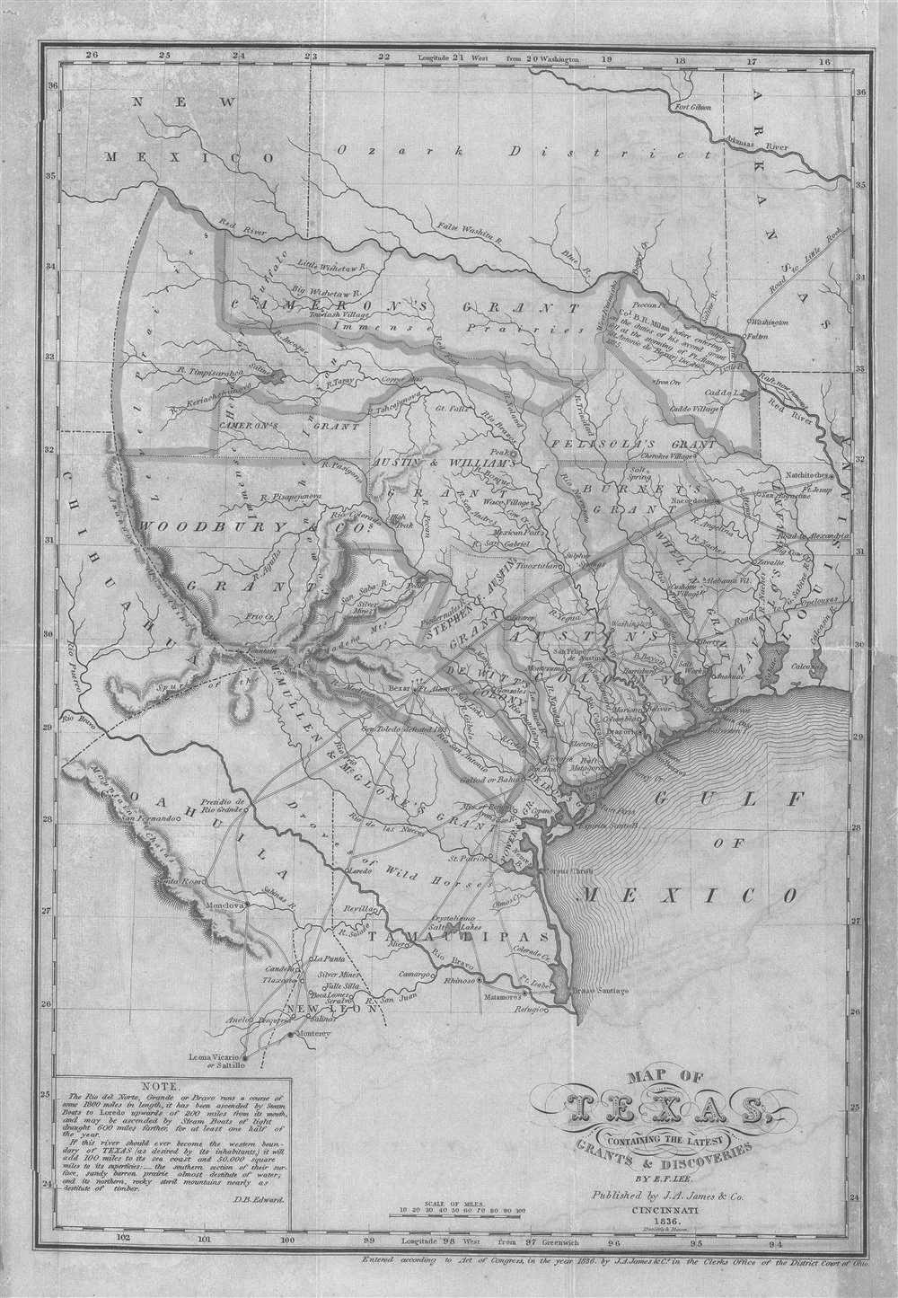
The 1836 Map of Texas Containing the Latest Grants & Discoveries by E. F. Lee is a historic map drawn by Edmund F. Lee and published in Cincinnati by J. A. James. Published February 1836.
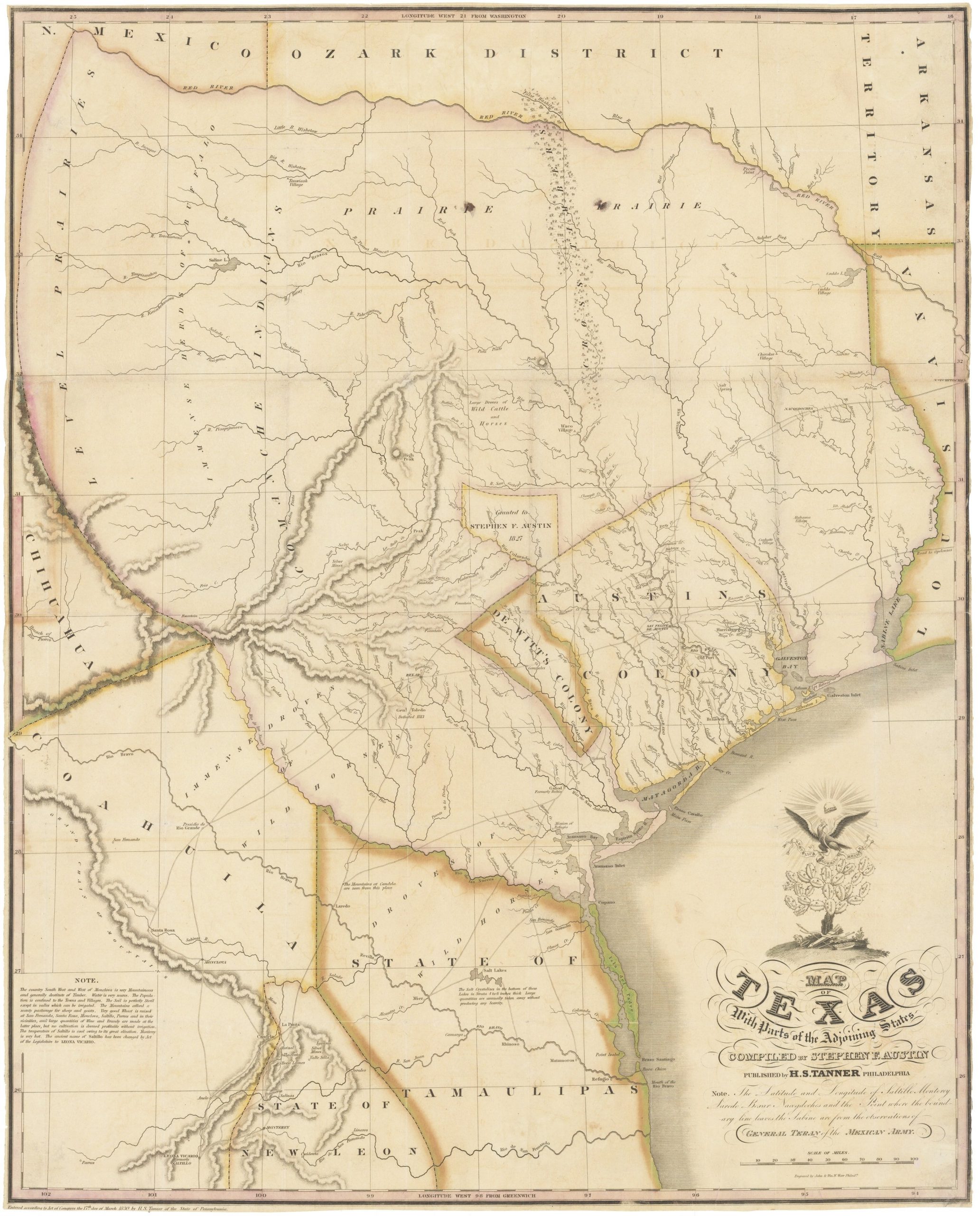
In particular, I remembered an 1836 map by E.F. Lee called Map of Texas Containing the Latest Grants and Discoveries. It almost copied Stephen Austin’s map of 1833.
Lee’s Texas didn’t go anywhere near Wyoming.
So I started following the maps.
Texas before Texas got bigger
Lee’s map was published in Cincinnati in 1836, one of the most consequential years in Texas history.
It shows rivers, roads, settlements, forts, empresario grants, Indian villages and parts of the Mexican states adjoining Texas. The Texas State Library notes something particularly interesting: Lee included a discussion of the Rio del Norte — the Rio Grande — and its possibility as the southwestern boundary of Texas.
Possibility.
That’s the word that matters.
Because the enormous Texas we see on later maps wasn’t simply the Texas everybody recognized at the beginning of 1836.
The boundary was still an argument.
Then history started moving rather quickly.
Texas declared independence from Mexico on March 2, 1836.
The Alamo fell March 6.
On April 21, Sam Houston’s army defeated Antonio López de Santa Anna at San Jacinto.
Santa Anna was captured.
On May 14 came the Treaties of Velasco.
Under the public agreement, Mexican troops were to withdraw beyond the Rio Grande. A secret agreement contemplated Santa Anna working to secure Mexican recognition of Texas independence and a permanent settlement of the boundary.
Mexico didn’t recognize the settlement.
Mexico didn’t even recognize the Republic.
This left Texas with the inconvenient problem of being an independent country according to Texas and still rebellious Mexican territory according to Mexico.
Houston, Austin and a very large idea
Stephen Austin’s 1830 map. Republished in 1840.
Sam Houston wanted the Rio Grande as the boundary of the new Republic.
Stephen F. Austin was thinking along similar lines.
In November 1836, Austin wrote that the “Rio Bravo ought to be the line.”
But Austin understood what following that river north actually meant. A Rio Grande boundary ran into established Mexican jurisdictions and settlements, including New Mexico. He considered alternatives if the Rio Grande claim couldn’t be obtained.
Then the First Congress of the Republic got involved.
On Dec. 19, 1836, Texas enacted its boundary claim.
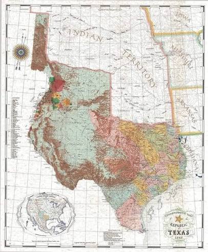
And this is where Texas got very large.
The Republic claimed the Rio Grande from its mouth all the way toward its source. From there, the claimed boundary continued north to the 42nd parallel and then followed the old boundary established between Spain and the United States.
Put that legal description over today’s state lines, and you get the magnificent Texas that started me down this rabbit hole.
Much of present-day eastern New Mexico.
Part of Colorado.
This map was by Texas artist and master cartographer John Davis to commemorate the 150th anniversary of the Texas Revolution in 1986. This shows what Texas adopted as its boundaries in December 1836.
Pieces of Oklahoma, Kansas and Wyoming.
Texas had solved its boundary problem.
It passed a law.
There was one small difficulty.
Mexico already claimed and governed much of the land Texas had just claimed.
Santa Fe discovers it is in Texas
Santa Fe is the perfect example.
Texas’s new boundary put Santa Fe inside Texas.
Nobody in Santa Fe had moved.
The city had not been conquered by Texas.
Texas wasn’t governing it.
Mexico was.
But according to the Republic’s map, there it was.
Texas eventually decided to do something about this.
President Mirabeau B. Lamar sponsored an expedition to Santa Fe in 1841, partly to open trade and partly to establish Texas jurisdiction over territory the Republic claimed under its 1836 law. The expedition numbered 321 people and carried 21 wagons and about $200,000 worth of merchandise.
It didn’t go well.
That story deserves its own telling, but the short version is that the Texans got lost, suffered terribly from shortages of food and water, arrived exhausted and discovered that New Mexico was not anxiously awaiting the arrival of its Texas government.
Mexican authorities captured them.
It was one thing to put Santa Fe inside Texas with a pen.
Getting Santa Fe to agree turned out to be considerably harder.
Texas joins the United States
Texas became the 28th state on Dec. 29, 1845.
The boundary question still wasn’t settled.
Mexico continued to reject the Texas claim, particularly the Rio Grande boundary.
Then came the Mexican-American War.
The war began in 1846 and ended with the Treaty of Guadalupe Hidalgo in 1848.
Mexico relinquished its claim to Texas. The international boundary followed the Rio Grande in the south, and Mexico ceded an enormous amount of western territory to the United States.
That included New Mexico.
So Mexico was finally out of the Texas boundary argument.
You might reasonably assume that settled things.
You would be underestimating Texas.
Now Texas argues with Washington
Texas still had its 1836 boundary law.
And Texas still claimed part of New Mexico.
So the argument changed participants.
Before 1848, Texas and Mexico disagreed over where Texas ended.
After 1848, Texas and the United States disagreed over where Texas ended.
This is one of my favorite parts of the story.
The United States had just finished fighting Mexico in a war partly bound up with the disputed Texas boundary.
Washington then found itself arguing with Texas about the disputed Texas boundary.
History occasionally has a sense of humor.
Texas claimed Santa Fe and a substantial portion of eastern New Mexico.
Washington did not concede the claim.
Neither did the people actually living there.
And the disagreement became serious.
By the summer of 1850, this was no longer just an argument over maps. Texas Gov. Peter Bell sought authority to send a military force into the disputed territory. President Millard Fillmore reinforced federal troops in New Mexico and made clear that if Texas militia entered to enforce the state’s claim, U.S. troops would resist them.
Fourteen years after independence, the country was still trying to answer a fairly basic question:
Where is Texas?
Unfortunately, slavery was underneath all of it
There was nothing amusing about the larger political problem.
The boundary fight had become part of the national crisis over slavery.
Texas was a slave state.
The United States had acquired an enormous amount of western territory from Mexico.
Congress was bitterly divided over whether slavery would be permitted to expand into it.
And there was a line on the map that every politician in Washington understood:
36 degrees, 30 minutes north latitude.
That was the Missouri Compromise line.
It also mattered to Texas.
When Congress approved Texas annexation in 1845, the resolution contemplated the possibility of additional states eventually being created from Texas territory. In any such states north of 36°30′, slavery was to be prohibited.
The giant Texas claim extended well north of that line.
Suddenly the question of whether a piece of land belonged to Texas or New Mexico wasn’t just an argument over surveying.
It was part of the national argument over slavery.
Maps had consequences.
Congress buys itself a smaller Texas
By 1850, Congress was trying to keep the Union from coming apart.
The result was the package of laws we call the Compromise of 1850.
California entered the Union as a free state.
New Mexico and Utah were organized as territories.
Washington, D.C., lost its slave trade, though not slavery itself.
A much stronger Fugitive Slave Act was enacted.
And Texas finally got a boundary.
On Sept. 9, 1850, Congress offered Texas a deal.
The northern boundary would begin where the 100th meridian crossed 36°30′ north, run west to the 103rd meridian, then south to the 32nd parallel, west to the Rio Grande, and from there follow the river to the Gulf of Mexico.
Look at those lines on a map.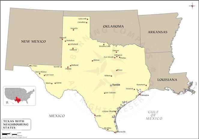
The Texas we know.
Texas agreed to relinquish all claims to territory outside the new boundaries.
The United States agreed to pay Texas $10 million in federal securities.
Washington had discovered an old and dependable method of settling a real-estate argument.
Money.
Three maps tell the story
Put three maps next to one another.
The first is E.F. Lee’s 1836 map.
Texas is already enormous.
It simply isn’t Texas enormous.
Lee even discusses the Rio Grande as a possible boundary.
Then look at a map based on the Republic’s December 1836 claim.
Texas suddenly reaches across New Mexico and Colorado and sticks that peculiar finger north toward Wyoming.
It’s a real historical map of a real historical claim.
But it needs a label:
Claimed by Texas.
Not necessarily governed by Texas.
Not accepted by Mexico.
Not later accepted by the United States.
Claimed.
Finally, look at Texas after the Compromise of 1850.
There is the familiar outline.
And looking at those maps reminds me of something else.
My family was in San Antonio in the 1700s.
They were there under Spain.
Then Mexico.
Then came the Republic of Texas.
Then the United States.
My family didn’t move every time the map changed.
The governments did.
Maybe that’s why old maps fascinate me.
They look so authoritative.
Draw a line. Put a name inside it. Add some color. Print the thing.
There.
History settled.
Except history doesn’t work that way.
The giant Texas reaching toward Wyoming wasn’t imaginary. The Republic really claimed it.
But Mexico contested it.
Texas couldn’t effectively govern much of it.
Then the United States disputed it.
It took independence, San Jacinto, the Treaties of Velasco, annexation, a war with Mexico, an argument with Washington and finally the Compromise of 1850 before the lines were settled.
So keep that wonderful giant map of Texas.
Just read the fine print.
That wasn’t necessarily Texas.
That was Texas’s idea of Texas.